Wildfire Smoke Basic
Modeling wildfire smoke in the U.S.A.
Multiple U.S. government agencies and academic research groups have created or adapted existing modeling systems to track the transport of wildfire smoke. A few examples are described below.
NOAA’s High-Resolution Rapid Refresh (HRRR) Smoke Modeling System
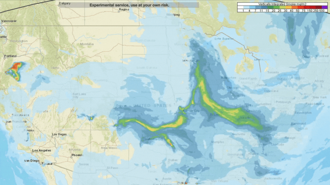
Figure 1. HRRR-Smoke Interactive Map Visualization showing vertically integrated smoke.
The High-Resolution Rapid Refresh Smoke (HRRR-Smoke) model is a three-dimensional coupled weather-smoke model based on the Weather Research and Forecasting model coupled to Chemistry (WRF-Chem). The dynamics and physics packages and settings for the meteorology of HRRR-Smoke are based on the experimental version of the HRRR model, which is run in real-time at NOAA/ESRL Global Systems Division (GSD). The HRRR-Smoke modeling system allows simulation of mesoscale flows and smoke dispersion over complex terrain, in the boundary layer and aloft at 3 km spatial resolution over the Contiguous United States (CONUS) domain and is updated every hour. The fire emissions are calculated using the fire detection and characterization data from the Visible Infrared Imaging Radiometer Suite (VIIRS) sensor on the Suomi National Polar-orbiting Partnership (S-NPP) and NOAA-20 satellites, as well as the Moderate Resolution Imaging Spectroradiometer (MODIS) instrument on the Terra and Aqua satellites.
For more information on HRRR-Smoke:
- HRRR-Smoke model description
- RAP- and HRRR-Smoke Operational forecasting models User’s guide
- HRRR-Smoke Field Graphics
- HRRR-Smoke Interactive Map Visualization
- HRRR Products (GRIB2 format)
NOAA’s HYSPLIT Atmospheric Transport and Dispersion Modeling System
NOAA’s Air Resources Laboratory (ARL) developed the Hybrid Single-Particle Lagrangian Integrated Trajectory (HYSPLIT) model, which is a modeling system that can compute simple air parcel trajectories as well as simulate complex transport, dispersion, chemical transformation, and deposition. The model calculation method has been developed over 30 years, and is a hybrid between the Lagrangian approach, using a moving frame of reference for the advection and diffusion calculations as the trajectories or air parcels move from their initial location, and the Eulerian methodology, which uses a fixed three-dimensional grid as a frame of reference to compute pollutant air concentrations.
The HYSPLIT model can be used to estimate the spatial and temporal transport of smoke, in the form of PM2.5, from a prescribed burn using only the location and area of burn as the input.
ARL is additionally developing the HYSPLIT-based Emissions Inverse Modeling System (HEIMS) to estimate wildfire emissions from the transport and dispersion of smoke plumes observed from NOAA’s GOES geostationary satellites. HEIMS uses the smoke patterns observed by these satellites to constrain the model under a four-dimensional variational (4D-Var) data assimilation scheme.
The HYSPLIT model can be run online or downloaded and run on one’s own computer.
For more information on HYSPLIT and its use in smoke modeling:
- HYSPLIT description
- HYSPLIT smoke calculations
- HYSPLIT-based Smoke Forecasting System
- HYSPLIT usage
- Kim, H. C., Chai, T., Stein, A., and Kondragunta, S.: Inverse modeling of fire emissions constrained by smoke plume transport using HYSPLIT dispersion model and geostationary satellite observations, Atmos. Chem. Phys., 20, 10259–10277, https://doi.org/10.5194/acp-20-10259-2020, 2020.
U.S. Forest Service BlueSky Smoke Modeling Framework
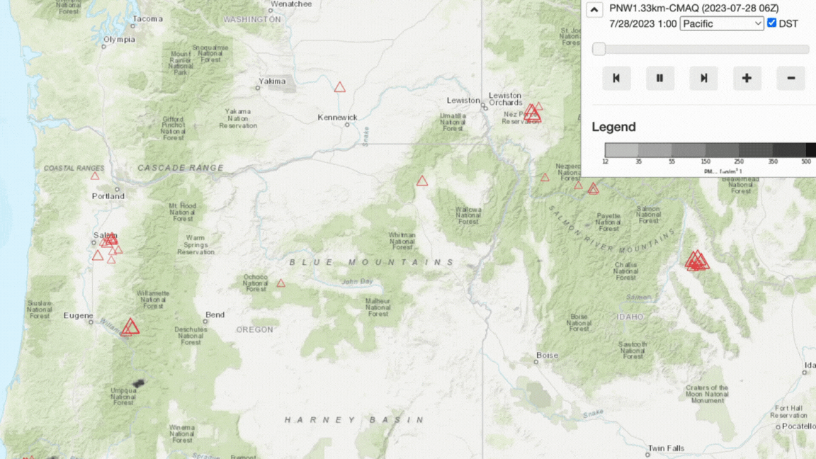
Figure 2. BlueSky viewer showing CMAQ Air Quality Model 1.33km smoke output for the Pacific Northwest domain.
BlueSky is a modeling framework that integrates numerous independent models of fire information, including fire emissions and smoke dispersion. The BlueSky Viewer allows users to visualize the output from the various models linked within the BlueSky modeling framework.
For more information on the BlueSky Modeling Framework:
- BlueSky Modeling Framework description
- BlueSky Daily Run Viewer description
- BlueSky Daily Run Viewer
WRF-SFIRE
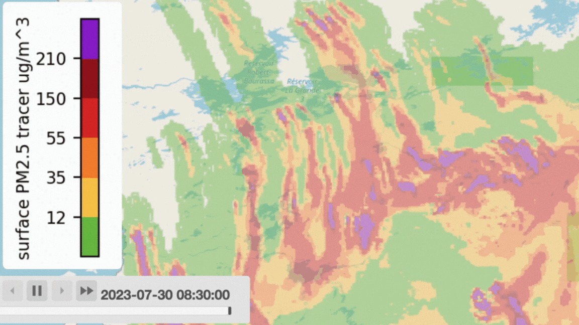
Figure 3. WRF-SFIRE web portal visualization of the 7/30/23 Eastern Canada Fire Complex simulations for surface PM2.5 tracer.
San Jose State University’s Wildfire Interdisciplinary Research Center (WIRC) fire modeling group develops and runs the coupled fire-atmosphere model (WRF-SFIRE). This modeling system simulates fire behavior as driven by meteorological forcing, and in turn the fire-affected winds are used to simulate the fire’s spread. With the additional coupling of WRF-SFIRE with WRF-CHEM, emission fluxes of chemical species and aerosols can be calculated to create smoke emissions and air quality forecasts.
For more information on WRF-SFIRE:
- WIRC Fire Modeling Group
- What is WRF-SFIRE?
- WRF-SFIRE code repository on GitHub
- WRF-SFIRE Web Portal for visualizing simulations
Additional Resources
The models described above are just a few that have been developed for simulating wildfire smoke. The Interagency Wildland Fire Air Quality Response Program provides a list of additional smoke models on their smoke tools site.
Guide prepared by K. Pitts (08/2023). For corrections or expansions please contact us.